
- Covid-19 Flow-Maps integrates data from known Covid-19 cases and citizen mobility.
- The tool can serve as support to the administrations, for decision making; to epidemiologists, to feed their models with updated data, and to citizens, to visualize the relationship of the pandemic, mobility and its associated risk.
- Flow-Maps is the new Barcelona Supercomputing Center (BSC) system for monitoring Covid-19 outbreaks and mobility-associated risk by integrating health information, population-level mobility patterns into a Geographical Information System.
The Covid-19 Flow-Maps platform integrates data on Covid-19 reported cases by the different Health Systems (Ministry of Health and health ministries of the governments of Castilla y León, Catalunya, Madrid, Navarra and País Vasco) and the population level mobility data from cell phone tracking from the Ministry of Transport, Mobility and Urban Agenda.
All the data in the system are georeferenced, which allows its representation on a map and facilitates its integration, analysis and interpretation.
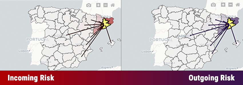
Covid-19 Flow-Maps allows to visualize the risk of Covid-19 infection in a certain area associated with the influx of citizens from other geographical areas.
The risk is calculated based on relating the known cases of Covid-19 with the data that tell us to which areas and with what intensity the citizens of the affected areas are moving. Mobility patterns are inferred from anonymized and aggregated mobile phone data by day and area of mobility.
Data are automatically updated as the administrations upload them into their public information systems and the detail of the information is offered at the provincial level, at the level of the whole of Spain, and at a smaller scale (areas or basic health zones) when this information is available, as is the case in the communities of Castilla y León, Catalunya, Madrid, Navarra and País Vasco.
Covid-19 Flow-Maps is an initiative of the Department of Life Sciences of the Barcelona Supercomputing Center (BSC) with an important contribution from those belonging to the INB/ELIXIR-ES, and its objective is to be helpful to health authorities when making decisions and also a tool available to epidemiologists and the general public.
Flow-Maps provides an integrated Geographical Information System (GIS) that can be accessed via a web interface or programmatically via our REST-API. On the top of systems, we developed an interactive dashboard that provides a number of novel analytical tools to monitor the state of the pandemic and to forecast the potential emergence of mobility-related outbreaks. Outbreak probability is estimated by calculating the Incoming Risk score which estimates the probability of disease expansion based on the relation between cases and movements between regions.
Miguel Ponce de Leon, Flow-Maps coordinator, says: “This is the first set of BSC tools to analyze, visualize and predict the behavior of the COVID-19 pandemic. We are working to integrate epidemiological models into the platform that feed on these data and allow progress in risk prediction”.
Alfonso Valencia, Prof ICREA, director of the BSC Department of Life Sciences and director of the INB/ELIXIR-ES, stresses: “The massive size of the mobility data, the peculiarities of the distributed health information and the integration with epidemiological models constitute a complex scenario, in which we can progress thanks to the enormous technical and computational capacities of the BSC”.
Covid-19 Flow-Maps has been developed with funds from the Department of Digital Policies and Public Administration of the Catalan Government, in collaboration with the Center for Innovation for DataTech and Artificial Intelligence (CIDAI); the Secretary of Digitization and Artificial Intelligence (SEDIA) of the Ministry of Economic Affairs and Digital Transformation, and the Spanish National Bioinformatics Institute - Institute of Health Carlos III (INB-ISCIII).
Visit website: https://flowmaps.life.bsc.es/flowboard
Original source: https://www.bsc.es/news/bsc-news/bsc%E2%80%99s-tool-visualize-the-relationship-between-the-citizens%E2%80%99-mobility-and-the-risk-covid-19-spreading